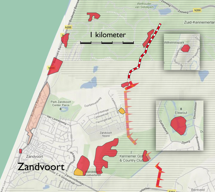
- toelichting
- Clarification
- Clarification
- Clarification
- Clarification
- toelichting
- Toelichting
- toelichting
- toelichting
- Clarification
- links
- Maps
- Map section IJmuiden - Zandvoort
- Map section Zandvoort
- Map section Waterleidingduinen
- Map section Waterleidingduinen - Zuid
- Map section Zandvoort - Katwijk
- Map section De Zilk
- Deelkaart Clingendael
- Deelkaart Kijkduin
- Deelkaart Meyendel
- Deelkaart Scheveningen
- Deelkaart Wassenaar
- Deelkaart Wassenaarseslag
- Map section Katwijk | Noordwijk
- Map section Katwijk Noord
- Map section Katwijk
- Map section Zandvoort - Katwijk
- Map section Zandvoort
- Map section Waterleidingduinen - Zuid
- Map section Waterleidingduinen
- Map section De Zilk
- Map section IJmuiden - Zandvoort
- Map section Huisduinen
- Map section De Kooy
- Map section De Donkere Duinen
- Map section Haven
- Map section Julianadorp
- Map section Zanddijk | Julianadorp
- Map section IJmuiden | Velsen-Zuid
- Map section oud-IJmuiden
- Map section Hoogovens
- Map section Beverwijk | Velsen-Noord
- Map section Westkapelle
- Map section Domburg
- Map section Oostkapelle
- Map section Nieuw Haamstede
- Map section Westerschouwen
- Map section Kop van Goeree
- Map section Ouddorp
- Map section Goedereede
- Map section Voornes Duin
- Map section Oostvoorne
- Map section Brielle
- Map section Haringvliet
- Map section Hellevoetsluis
- Map section Monster
- Map section 's Gravezande | Naaldwijk
- Map section Maasdijk
- Map section Waterweg
- Map section Waterweg | Hoek van Holland
- Map section Valkenburg
- Map section Berkheide
- Map section Noordwijkerhout
- Map section De Dennen | Den Hoorn
- Map section Freie Küste Den Helder - Callantsoog
- Map section Callantsoog
- Map section De Hors | Den Hoorn
- Map section De Koog
- Map section De Mok
- Map section Den Burg
- Map section Eierland
- Map section Freie Küste Den Helder - Callantsoog | Oost
- Map section Oudeschild
- Map section Petten
- Map section Westerslag | De Dennen
- Map section Slufter | Vliegveld
- Map section Schagen
- Map section Bergen
- Map section Bergen aan Zee
- Map section Groet
- Map section Fliegerhorst Bergen
- Map section Schoorl
- Map section Castricum aan Zee
- Map section Bakkum | Castricum
- Map section Egmond a/Zee | a/d Hoef
- Map section Heemskerkerduin
- Map section Egmond Binnen
- Map section Breskens
- Map section Dishoek Koudekerke
- Map section Koudekerke
- Map section Rammekens
- Map section Vlissingen Binnenhavens
- Map section Vlissingen Nollebosch
- Map section Westkapelle
- Map section Middelburg
- Map section Afsluitdijk
- Map section Dorp
- Map section Duinen
- Map section Holwierde | Delfzijl
- Map section Hollum
- Map section Hoorn | Oosterend
- Map section Midsland
- Map section Kornwerderzand
- Map section Oost-Vlieland
- Map section Oosterend
- Map section Posthuys
- Map section Stuifdijkpad
- Map section Termunterzijl
- Map section Vlieland Midden
- Map section West-Terschelling
-
legenda
Extant German emplacements
Sea front
German emplacements no longer present
Anti-tank wall still present
Demolition zone
Land front no longer present
Land front still visible
- punten op de kaart


Demolition and evacuation
The construction of coastal defenses resulted in large-scale urban demolition along the seaside boulevard. In Zandvoort alone, 648 buildings were razed and 7,738 residents were forced to evacuate.
Zandvoort was rebuilt after the war but Haarlem architect Friedhoff’s ambitious plans for a classy new resort were never realized. What did get built was the Bouwes Palace Hotel. In spite of its towering height, it is regarded as a sorry architectural low point, remarkable only for its lack of character and imagination. The old village was partly restored. The defense works, mostly located in the dunes, were left undisturbed if they did not interfere with reconstruction efforts. The 1953 flooding disaster triggered the removal of bunkers located directly on the beach.

W.N. 163 - Park Kostverloren
The anti-tank wall along the eastern edge of Stützpunktgruppe Zandvoort
Widerstandsnest 143c - Headquarters of the Festung Pionier Stab
Widerstandsnest 151
W.N. 161 / W.N. 162
Walzkörpersperre